In this blog post, we will discuss the importance of Geocoding and how to use mapping tools to identify the most accurate location of an event. Moreover, we will look at how the process of geocoding can be automated using Artificial Intelligence (AI) and at its limitations.
What is Geocoding?
Geocoding is the process of adding geographical identification metadata to various media such as text, photos, videos, etc. It is a powerful tool for tracking and analyzing events and is essential in writing accurate threat alerts.
Why is Geotagging Important?
Identifying the most accurate location of an event is extremely important. People in charge of physical security are interested in knowing how far from their office, hotel or production area a security incident took place, and they might not receive a notification (i.e. an alert) if the event is wrongly geotagged. Conversely, they might be alerted of an incident that occurred somewhere else, hence producing information noise. Therefore, it is crucial to geotag the event as accurately as possible, and whenever possible, at the street level or Point of Interest (POI) level.
Tools and Techniques for Identifying Accurate Locations
In order to identify the most accurate location of an event, analysts use a set of tools and techniques on a daily basis. The following are some of the free, and most commonly used, mapping tools:
Google Maps (of course!)
Google Maps is the most obvious tool to search for locations. Here are some useful tips on how to use Google Maps:
a. Find coordinates of a location: Sometimes, you might not find the exact address of the event on Google Maps, but you can still visualize it. In this case, you can extract the coordinates from Google Maps by following these steps:
i. Once you have identified an exact POI (e.g. port, road intersection, village) for which you cannot find an address on Google Maps, mouse over the map, then right-click with your mouse (or secondary click if you are on a Mac).
ii. Click on the coordinates to copy them.
b. Measure distance from a location: Sometimes, an incident occurs in a remote location for which you do not have an address or POI to look for. However, the sources that you have identified might give you some clues, such as the distance from a known location. In these cases, you can look for the place using the measure distance feature on Google Maps by following these steps:
i. Search for the known location on Google Maps.
ii. Right-click with your mouse (or secondary click if you are on a Mac), then click on “measure distance”.
iii. Drag the line to the right distance (km/miles).
iv. Look around the map to find the location you are looking for (switch between street and satellite view, as often they display different labels)
v. Right-click again and copy the coordinates.
Wikipedia
Wikipedia is a free online encyclopedia that is useful for finding information about locations such as the name in the local language, administrative divisions, and coordinates. Here are some tips on how to use Wikipedia:
a. Find the location’s name in the local language: If you are unable to find a location on Google Maps by searching for its name in English, try looking for it in the local language by following these steps:
i. Search for that location on Wikipedia and look for the name in the local language.
ii. Then, use that name in your queries on Google Maps.
Wikipedia also provides coordinates via a library called GeoHack, which you can use to identify coordinates.
OpenStreetMap
OpenStreetMap is a free and open-source map of the world that is maintained by volunteers. It includes information on roads, buildings, and other features. OpenStreetMap is often used by organisations that work in the field (e.g. NGOs) to tag remote locations than cannot be found on Google Map.
Wikimapia
Similar to OpenStreetMap, Wikimapia is another useful tool that allows searching for specific “categories” such as villages, infrastructures, etc. and provides their coordinates.
Mapcarta
Mapcarta is a map of the world that includes information on tourist attractions, hotels, and other POIs. It can be useful when trying to identify the location of a hotel or tourist attraction.
Mindat
Mindat is a database of minerals, rocks, and other geological information. It can be useful when trying to identify the location of a mine or quarry.
Longdo
Longdo is a map of Thailand that includes information on roads, buildings, and other features. It can be useful when trying to identify the location of a POI in Thailand.
Baidu
Baidu is a Chinese search engine that includes maps of China. It can be useful when trying to identify the location of a POI in China.
Tools to monitor natural disasters
In the case of natural disasters, it is important to identify the location and magnitude of the event as accurately as possible to assess the level of risk and potential impact. Here are some useful tools to monitor natural disasters:
GDACS
The Global Disaster Alert and Coordination System (GDACS) provides alerts, impact assessments, and situational information for all types of natural disasters, including earthquakes, tropical cyclones, and tsunamis. It is maintained by the European Commission’s Joint Research Centre and the United Nations Office for the Coordination of Humanitarian Affairs (OCHA).
GDACS provides information on the location, magnitude, and impact of natural disasters. It also includes a map that allows you to see the affected areas and the estimated population at risk. GDACS also provides real-time updates on the situation and alerts for new events.
USGS
The United States Geological Survey (USGS) provides real-time updates on earthquake activity around the world. It also provides information on the magnitude, depth, and location of earthquakes. The USGS website allows you to search for earthquakes by location, magnitude, and time. It also includes maps that show the affected areas and the intensity of the shaking.
China Earthquake Network
The China Earthquake Network provides real-time updates on earthquake activity in China. It provides information on the magnitude, location, and impact of earthquakes. The China Earthquake Network website allows you to search for earthquakes by location, magnitude, and time. It also includes maps that show the affected areas and the intensity of the shaking.
How to use Artificial Intelligence to automate geocoding
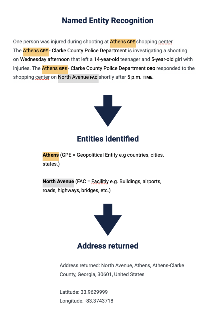
At Hozint, the geocoding process has been fully automated through the use of Artificial Intelligence (AI). Our risk intelligence platform is powered by AI software that is capable of identifying the locations mentioned in a text and automatically geotags an alert on the map. This is done via a process called Named Entity Recognition (NER). The AI runs through the text of an article and extracts “entities” which refers to locations such as countries, cities, streets and Points of Interest (POIs). Then, it looks for those entities in mapping libraries (e.g. Google map, Open Street Map) and will return coordinates.
This process takes only a few seconds, allowing analysts to focus their efforts on analyzing the data rather than spending time manually identifying locations. The result is a highly efficient system that optimizes the work of analysts who are working on specific geographical areas.
Limitations of the use of AI in Geocoding
Although AI can significantly streamline the geocoding process, it is not without limitations. One of the major issues is that AI can tag the wrong location due to the ambiguity of location names. For example, there are several cities and towns across the world with identical names such as Springfield or Paris, which can lead to confusion. Even within the same country, some cities or towns might have identical names, making it difficult for AI to determine the exact location. Additionally, when multiple locations are mentioned in the text, the AI may struggle to identify the relevant one. Therefore, it is always essential for analysts to verify the information provided by the AI. AI can be seen as an extension of an analyst’s brain, but it cannot replace the critical thinking and judgment of a human expert….for now at least.